
Thematic Map Gallery
IndianaMap is the public source for Indiana map data. The Thematic Map Gallery helps people find commonly used maps for a better understanding of Indiana issues and trends.
-
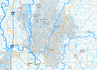
House Districts
(118th Gen. Assembly)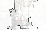 Shows the legislative district boundaries for the House of Representatives, 118th General Assembly of Indiana.
The boundaries were redistricted and adopted in 2011 (current until 2021), and were provided by personnel of the Indiana Election Division.
Please select a district number of interest from the dropdown menu to launch the customized IndianaMap viewer showing the district. Click inside the district boundary to find the name and contact information of the representative, or add other layers of interest from the “Add Content” menu.Disctrict Number:
-
Senate Districts
(118th Gen. Assembly)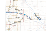 Shows the legislative district boundaries for the Senate, 118th General Assembly of Indiana.
The boundaries were redistricted and adopted in 2011 (current until 2021), and were provided by personnel of the Indiana Election Division.
Please select a district number of interest from the dropdown menu to launch the customized IndianaMap viewer showing the district. Click inside the district boundary to find the name and contact information of the representative, or add other layers of interest from the “Add Content” menu.Disctrict Number:
-
Congressional Districts (113th Congress) 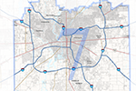 Shows the legislative district boundaries in Indiana for the 113th U.S. Congress.
The boundaries were redistricted and adopted in 2011 (current until 2021), and were provided by personnel of the Indiana Election Division.
Please select a district number of interest from the dropdown menu to launch the customized IndianaMap viewer showing the district. Click inside the district boundary to find the name and contact information of the representative, or add other layers of interest from the “Add Content” menu.Disctrict Number:
-
Data Sharing Initiative Layers
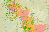
 Shows the IndianaMap Data Sharing Initiative (DSI) layers provided by the Indiana Department of Homeland Security (Data were last harvested on October 13, 2014). These data overlay an IndianaMap "Dark Color Hillshaded Relief" Base Map and "Best Available Imagery" for Indiana (set with transparency).
These data sets were compiled as part of the EIGHTEENTH data harvest of the 'IndianaMap Data Sharing Initiative' between IGIC, Indiana Office of Technology (IOT), Indiana Geographic Information Office (GIO), Indiana Department of Homeland Security (IDHS), Indiana Geological Survey (IGS) and participating Indiana counties to provide the most accurate framework data (including address points, street centerlines, land parcels, and governmental boundaries) for the citizens of Indiana.
Data are current as of October 14, 2014. Updates are posted periodically.
-
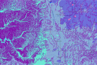
National Hydrography Data (NHD) (1:2400)
 Provides access to the local-resolution version of the National Hydrography Dataset (NHD) for Indiana, showing the currently available data as of November 6, 2014. The map contains rivers, streams, and lakes mapped at a scale of 1:2400 along with the 2009 HUC08 watershed boundary layer for reference. The NHD dataset is currently incomplete but includes data for the following twenty-one HUC08 subbasins in Indiana: 04100007 (Auglaize), 05140104 (Blue-Sinking), 05120204 (Driftwood), 05120203 (Eel), 05120104 (Upper Eel), 05120205 (Flatrock-Haw), 0712002 (Iroquois), 05120208 (Lower East Fork White), 05080002 (Lower Great Miami), 05120113 (Lower Wabash), 05120202 (Lower White), 04100005 (Upper Maumee), 05120111 (Middle Wabash-Busseron), 05120105 (Middle Wabash-Deer), 05120207 (Muscatatuck), 04100004 (St. Marys), 05120110 (Sugar), 05120206 (Upper East Fork White), 05080001 (Upper Great Miami), 05120201 (Upper White), and 05120107 (Wildcat).
-
Wind Speed and Elevation Contours
 Provides access to wind resource of Indiana and finding suitable sites for wind energy projects. Conventional field techniques of wind resource assessment can be time consuming, however, and often depend heavily on local meteorological expertise as well as the availability of reliable and representative wind measurements.
-
Oil and Gas Wells
 Provides access to petroleum well data created from data in the Indiana Geological Survey (IGS) Petroleum Well Database, which is a component of the IGS Petroleum Database Management System (PDMS). The petroleum field dataset was created by comparing digital lines from Indiana Geological Survey Miscellaneous Map 58 (MM58) with one quarter mile buffers of productive petroleum wells. New petroleum field outlines were then manually digitized on screen using the shape information from MM58 and the buffer extents. The Silurian reef points and polygons were derived and modified from a preexisting published paper Map of Indiana Showing Thickness of Silurian Rocks and Location of Reefs, Indiana Geological Survey Miscellaneous Map 54.
-
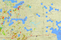
Industrial Mineral Sites
 The distribution of stratigraphic data for various industrial minerals and industrial mineral sites in Indiana. Data were derived from cores, measured samples, mine samples, outcrops, quarries, and well logs. The abandoned quarries, 1998 shows abandoned quarry locations that have locational information that is adequate to determine coordinate values and were derived from information in Indiana Geological Survey Computer Database 2. The Abandoned Sand and Gravel Pits shows the locations of abandoned sand and gravel pits, including 2,275 of 2,515 sand and gravel pit locations from the 'Abandoned Sand and Gravel Pit Database' of the Indiana Geological Survey. The active industrial mineral operations show the locations of industrial mineral operations that were active in 2001 in Indiana.
-
Karst Features
 Sinkhole areas (SHA) and sinking-stream basins (SSB) associated with rocks of Silurian, Devonian, and Mississippian age in southern Indiana. It shows sinkhole areas larger than 80 acres. Cave entrances per square kilometer shows the density (i.e., number of entrances per square kilometer) of mapped cave entrances in Silurian, Devonian, and Mississippian rocks in southern Indiana. Locations of individual cave entrances are not shown. Input and Detection Points for Selected Subsurface Dye Traces, 1999 (1:24,000) - Shows the locations of input and detection points that were used for selected subsurface dye-trace investigations in southern Indiana. Springs in South-Central Indiana, 1997 (1:126,720) - Shows the locations of springs in and around the karst region of south-central Indiana. The data should not be used for site-specific data analysis.
-
Demographics
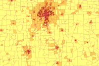 The Indiana Demographic Map uses various IndianaMap services including:
Census Blocks, 2000 (1:500,000)
Census Blockgroups, 2000 (1:100,000)
County Census Data, 2000 (1:24,000)
Census Tracts, 2000 (1:100,000)
American Indian Ethnicity, 2000 (1:500,000)
Asian Ethnicity, 2000 (1:500,000)
Black Ethnicity, 2000 (1:500,000)
Hispanic Ethnicity, 2000 (1:500,000)
White Ethnicity, 2000 (1:500,000)
Age (Median) from Census Blockgroups, 2000 (1:100,000)
Historical Populations and Population Densities, 2000 (1:500,000)
Historical Changes of Population Densities, 2000
Children in Poverty, by School District, 2000
Population Density of Blockgroups, 2000
Family Size (Average) by Census Blockgroups, 2000
-
Indiana Bedrock Geology
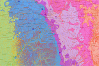 The Indiana Bedrock Map uses services from IndianaMap including:
Geologic Faults, 2002 - Shows the locations of geological fault traces in Indiana. Source data scales range from 1:12,000 to 1:500,000 with the majority being taken from sources with a scale of 1:63,360 or larger.
Bedrock Topography, 1982 (1:500,000) - Shows contours that define the elevation (feet above sea level) of the bedrock surface in Indiana. Contour interval is 50 feet. Digitized and modified from the following published paper map: Indiana Geological Survey Miscellaneous Map 36.
Bedrock Geology, 1987 (1:500,000) - Shows systems and selected groups, formations, and other stratigraphic units. Generalized lithologic characterizations are also provided, as well as hyperlinks to the Compendium of Paleozoic Rock-Unit Stratigraphy in Indiana. Digitized from the following published paper map: Indiana Geological Survey Miscellaneous Map 48.
-
Airports
 The Indiana Airports Map uses IndianaMap services including:
Public-Use Airports, 1998 - Shows 642 aircraft landing facilities in Indiana, obtained from National Transportation Atlas Database (NTAD), Bureau of Transportation Statistics (BTS). Attributes include the physical and operational characteristics of the landing facility, current usage ncluding enplanements and aircraft operations, congestion levels and usage categories.
Public-use Airports, 2005 - Shows locations of 109 public-use airports in Indiana, derived from data provided by personnel of the Indiana Department of Transportation (INDOT), Aeronautics Section. Personnel of INDOT obtained the data from the airport application/ FAA Master Record on file at the Indiana Department of Transportation, Aeronautics Section. The data is collected as part of the application for an airport site.
Airport Boundaries and Runways, 2006 (1:100,000) - Shows boundaries and runways for 143 airports in Indiana (provided by ESRI). All airports have a boundary and most have at least one runway. Provides names and feature classification codes, as well as information regarding use, elevation, congestion level, service level, hub size, and tower type.
-
Critical Facilities Data
 The Critical Facilities Data – Multi-Hazards Mitigation Map uses IndianaMap services includeing:
Fire Station Facilities in Indiana (MHMP), 2011 - Shows locations of fire station facilities in Indiana, derived by The Polis Center as part of several 'DMA2000 Multi-Hazard Mitigation Planning' (MHMP) projects, from data of the 'Hazards U.S. Multi-Hazards' (Hazus-MH MR1, v 1.1) program (data from 2003) developed by the Federal Emergency Management Agency (FEMA).
Police Station Facilities in Indiana (MHMP), 2011 - Shows locations of police station facilities in Indiana, derived by The Polis Center as part of several 'DMA2000 Multi-Hazard Mitigation Planning' (MHMP) projects, from data of the 'Hazards U.S. Multi-Hazards' (Hazus-MH MR1, v 1.1) program (data from 2003) developed by the Federal Emergency Management Agency (FEMA).
Medical Care Facilities in Indiana (MHMP), 2011 - Shows locations of medical care facilities in Indiana, derived by The Polis Center as part of several 'DMA2000 Multi-Hazard Mitigation Planning' (MHMP) projects, from data of the 'Hazards U.S. Multi-Hazards' (Hazus-MH MR1, v 1.1) program (data from 2003) developed by the Federal Emergency Management Agency (FEMA).
School Facilities in Indiana (MHMP), 2011 - Shows locations of school facilities in Indiana, with the exception of some universities. Derived by The Polis Center as part of several 'DMA2000 Multi-Hazard Mitigation Planning' (MHMP) projects, from data of the 'Hazards U.S. Multi-Hazards' (Hazus-MH MR1, v 1.1) program (data from 2003) developed by the Federal Emergency Management Agency (FEMA).